Affiliate links on Android Authority may earn us a commission. Learn more.
How to measure distance on Google Maps
Published onApril 7, 2024
An underrated feature in Google Maps is the ability to measure the distance between two or more points. It can aid tremendously with planning, whether you’re aiming to walk or go on a road trip. Here’s how to measure distances on Google Maps.
QUICK ANSWER
- To measure distance in the desktop version of Google Maps, right-click on your starting point, then choose Measure distance. Next, click to trace the path you'd like to gauge.
- Using the Google Maps mobile app, tap and hold to drop a pin and select Measure distance from the location's description. Move the crosshairs to calculate distance.
KEY SECTIONS
How to measure distance in Google Maps on your computer
The first thing to check is if you’re using Maps in Lite mode. If there’s a lightning bolt at the bottom of your screen, you’re in Lite mode, meaning you won’t be able to measure the distance between points. Open the full version of Google Maps from your web browser.
- Select a starting point on the map, whether a specified location or a custom pin. Then, right-click on that point and select Measure distance from the drop-down menu.
- Then, click on another point on the map to calculate the distance between them. You chain together as many points as possible to calculate the total length.
- If you make a mistake, you can click a point to remove it. Alternately, you can move a point by clicking and dragging it. This is helpful for improving accuracy, especially since Google Maps doesn’t account for obstacles or terrain that might be present in the real world.
- The total distance is displayed at your last point, and in the box at the bottom. When you’re done measuring distance, click the X icon.
How to measure distance in Google Maps (iPhone or Android)
- Open the Google Maps app on your mobile device. Touch and hold anywhere on the map to drop a red pin as your starting point. Then, from the location description, tap Measure distance.
- Next, move the map to set the black crosshairs on a subsequent point. Tap Add point. You can add as many points as you like, and the total distance is displayed at the bottom of the screen.
To remove the last point you added, tap the Undo arrow. To remove all points, in the top-right corner, tap the triple-dot icon and then Clear.
Calculate square feet or meters on Google Maps
You don’t (necessarily) have to hire professionals to get an estimated measurement of a piece of land. Google Maps can help you measure plots of any shape in square feet or meters using the same measure distance tool.
We recommend using the Google Maps desktop site, since it calculates the area for you, which can be especially helpful for shapes that aren’t square. If your math skills are up to snuff, there’s no reason you can’t multiply raw length and width measurements in the mobile app, naturally.
- On a computer, zoom in on the place you want to measure.
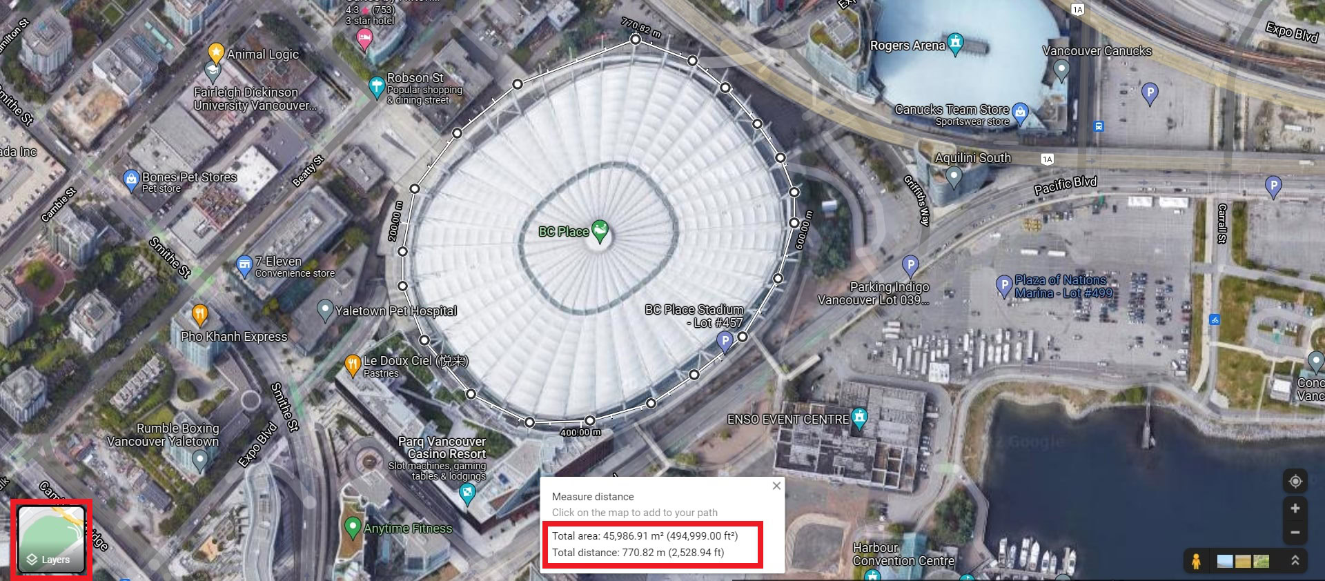
- Next, it’s helpful to switch to Satellite mode via the Layers tile on the left to see the actual form of the land.
- Right-click on the corner of a building or land space you’d like to measure and select Measure distance.
- Left-click to add more points along the border until you connect with your starting point. The more points you add, the more precise the area will be.

Once you create a complete boundary, Google will calculate the land size in square feet or meters in the box below. Each point is draggable, so you can adjust for further precision. To remove a point, click it. You can also use Google Earth to measure any part of a map’s length, width, and area.
FAQs
While not perfect, the Google Maps distance measurement tools are sufficiently accurate for most purposes. Google Maps aligns its digital map surface with the earth’s GNSS (Global Navigation Satellite Systems) scale to measure the distance.
Yes, you can use the measure distance tool to trace your walking route and calculate how far you walked. It might be worth investing in a Fitbit band if you want to keep track of all your stats while walking or running.
Yes, Google Maps can calculate the distance between two or more points. Just right-click on your starting point, choose measure distance, and select points on the map to measure.
Google Maps can only measure the distance between two or more points on a map. To calculate smaller length measurements, use Side Meter on your phone.